Homepage ×
Properties for sale Apartments for rent New Development Serviced Apartments Overseas Properties
Offices for sale Offices for rent Coworking Space Serviced Office
Mortgage Calculator
Build Your Business
Spacious
1,000+ Reviews
Install

Table of Contents

Toggle table of contents dropdown
Search Icon
Search Icon
Loading indicator

No results found

Simple Hong Kong's New MTR Map / Railway Lines Handbook

Hong Kong Living | September 30, 2016

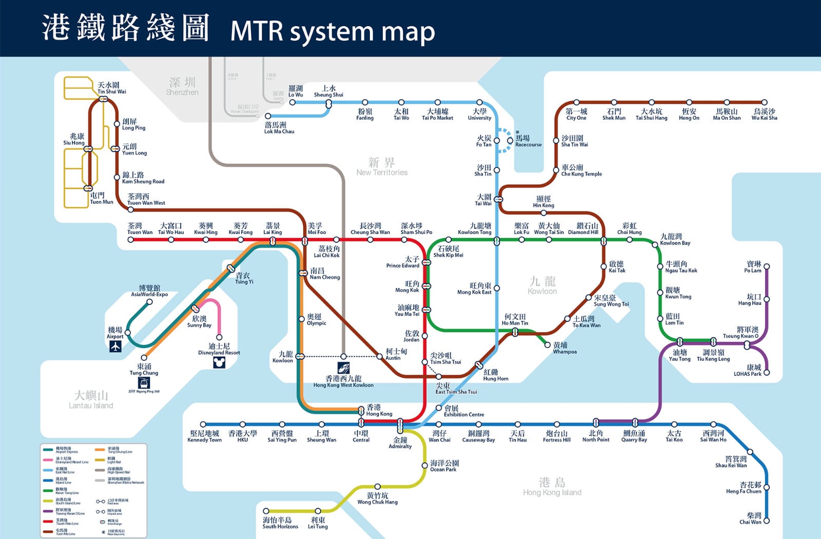
Hong Kong is blessed with one of the world’s most efficient public transportation systems, and you can get to most places in Hong Kong easily with the city’s metro system – the MTR (Mass Transit Railway). While MTR system consists of impressive 11 lines, 87 stations and 68 Light Rail stops, there are still places that have not been accessible by MTR. However, we’ve been hearing good news – that the train system is expanding! Several future projects on the MTR have been put forward by the MTR Corporation to the Hong Kong Government, with some already under construction.

You can learn about the newest project from the information we have directly retrieved from Official Hong Kong MTR website,

Railway Development Strategy

The Government’s Railway Development Strategy 2014 (RDS-2014) is the first major Hong Kong railway development since 2000. Within the next decade based on (1) recommendations from advisors & views collected from the public and (2) various factors (including land use planning, environmental impacts and financial viability etc), the Corporation will complete seven new strategic rail extensions. They include:

mtr map

  1. Northern Link –

 Kam Sheung Road  (West Rail Line) ⟷ Kwu Tung (Lok Ma Chau Spur Line)

2. Hung Shui Kiu Station 

Tin Shui Wai ⟷ Hung Shui Kiu Station ⟷ Siu Hong Station (West Rail Line)

3. Tung Chung West Extension –

New station @ Tung Chung West

4. Tuen Mun South Extension – 

New station @ Tuen Mun South

5. East Kowloon Line – 

Diamond Hill Station (Kwun Tong Line & the future Shatin ⟷ Central Link) ⟷ Po Lam (Tseung Kwan O Line)

6. South Island Line (West) – 

South Island Line (East) ⟷ West Island Line

7. North Island Line – 

Tung Chung Line (East) ⟷ Tseung Kwan O Line (West)

(Source: Hong Kong MTR Corporation Limited)

More information and maps at the Wikipedia page on Future Projects of the MTR.

WhatsAppFacebookWeChatGmailCopy LinkShare

Extend Reading

Subscribe for the latest property advice

Stay updated on the latest developments and tips in the property market to make more informed decisions

Please provide a correct email address

Recommended Articles

Hong Kong Living | February 5, 2016

Yau Ma Tei - Explore the Hong Kong local culture

Yau Ma Tei, an old district situated in this cosmopolis, has its unique landscape and culture. Sitting in between the MTR station Mong Kok and Jordan, Yau Ma tei has a huge convenience for commuting. It also offers a relative lower rent and a more relaxing vibe compared with the vicinity. It is a residence neighborhood, with G-2 Floor served […]

Hong Kong Living | June 23, 2020

Buying a Car in Hong Kong – 10 Tips to Help You Out

Buying a car in Hong Kong might seem an expensive indulgence to many. After all, the city is extremely well-connected and boasts one of the world’s most economical and modern public transport systems. Why, then, would anyone need to own a car? Start with convenience. With your own car, you’ll be able to travel anywhere you want, anytime you want. […]

Hong Kong Living | March 10, 2016

Hiking in Hong Kong - 4 trails you shouldn't miss

As crowded and advanced Hong Kong might seem, it also has its countryside and rural area. Surprisingly, it possesses around 70% of green area with respect to its territory and there are quite a few hiking trails scattering around in the outskirt of Hong Kong. With the diversified topography, every hiking trail has its own characteristic and some attractions worthy […]